
Instant Remote Measurements
Accurate Property Measurements Without Leaving Your Desk
SiteRecon's remote takeoff measurements deliver 95-98% accurate square footage, linear feet, and service areas from high-resolution aerial imagery—so you can quote faster, bid more jobs, and protect your margins from day one.
Everything You Need to Measure, Map, and Win More Bids
Instant Measurements
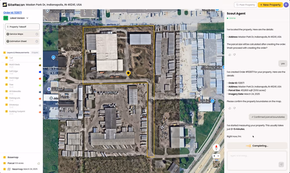
Measure turf, hardscape, beds, parking lots, and snow routes remotely using satellite and aerial imagery. Get accurate square footage and linear measurements in minutes instead of hours—no truck rolls, no wasted windshield time.
Multi-Layer Service Mapping
Create detailed property maps with distinct layers for every service type—mowing zones, irrigation coverage, snow priority routes, bed maintenance areas. One measurement session captures everything your crews need to estimate and execute.
Bulk Property Processing
Measuring a portfolio of 50 properties? Upload your list and get complete takeoffs back fast. Scale your estimating capacity without adding headcount—perfect for large commercial bids and multi-site contracts.

Instant Measurements
Measure turf, hardscape, beds, parking lots, and snow routes remotely using satellite and aerial imagery. Get accurate square footage and linear measurements in minutes instead of hours—no truck rolls, no wasted windshield time.
Multi-Layer Service Mapping
Create detailed property maps with distinct layers for every service type—mowing zones, irrigation coverage, snow priority routes, bed maintenance areas. One measurement session captures everything your crews need to estimate and execute.
Bulk Property Processing
Measuring a portfolio of 50 properties? Upload your list and get complete takeoffs back fast. Scale your estimating capacity without adding headcount—perfect for large commercial bids and multi-site contracts.
What our customers are saying about SiteRecon
"With SiteRecon we can process 10 or 20 opportunities in a week instead of 5, and our close rate has increased from 10% to 25%."

Integrations That Fit the Way You Work

Aspire
Lorem ipsum dolor sit amet, consectetur adipiscing elit. Suspendisse varius enim in eros elementum tristique. Duis cursus, mi quis viverra ornare, eros dolor interdum nulla, ut commodo diam libero vitae erat.
BOSS
Lorem ipsum dolor sit amet, consectetur adipiscing elit. Suspendisse varius enim in eros elementum tristique. Duis cursus, mi quis viverra ornare, eros dolor interdum nulla, ut commodo diam libero vitae erat.
Integrations That Fit the Way You Work
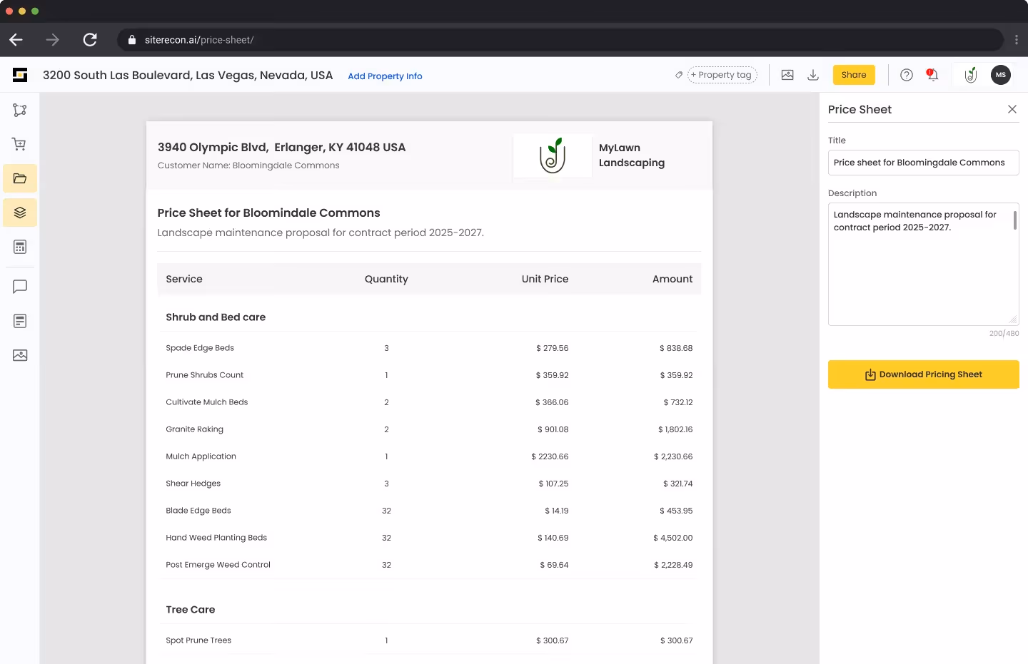
Push your remote measurements directly into Aspire estimates. No manual data entry, no transcription errors—just accurate property data flowing seamlessly into your production rates and pricing models.
Connect SiteRecon measurements to Real Green for lawn care and plant health programs. Calculate precise application rates and material quantities based on actual measured areas, not guesswork.
Explore other features
Frequently Asked Questions About Remote Takeoff Measurements
SiteRecon's AI instant remote measurements deliver 90-95% accuracy using high-resolution aerial and satellite imagery—often more consistent than manual on-site measurements with wheel measurers or pacing. Our AI cross-references multiple data sources and imagery layers to ensure precision, and you can verify or adjust any measurement before finalizing your estimate.
You can measure virtually any outdoor surface: turf areas, hardscapes, parking lots, sidewalks, planting beds, tree and shrub zones, snow removal routes, irrigation coverage, and property perimeters. SiteRecon handles residential lawns, commercial campuses, HOA communities, retail centers, industrial facilities, and multi-site portfolios across all seven outdoor service verticals.
With SiteRecon's self-service remote measurement AI tool, you can complete measurements yourself in as little as 3-10 minutes per property. For large commercial properties with custom service layers or when your estimating team is at capacity, alternatively many of our clients choose our expert measurement services that result in verified takeoffs within 24-48 hours,
Yes. SiteRecon's bulk measurement processing lets you upload a list of property addresses and receive complete takeoffs for the entire portfolio. This is how contractors scale from bidding 5 properties a week to 50 without adding estimating staff or spending days on site visits.
Absolutely. SiteRecon creates service-specific measurement layers including snow priority routes, salt/sand coverage zones, parking lot square footage, sidewalk linear feet, and obstacle mapping. You can generate accurate snow contracts using summer imagery, so you're not scrambling to measure properties after the first frost.
Get Started Today
Ready to cut your estimating time by 75% and quote more jobs without more windshield time?