Map, Measure, Estimate, Bid and Win in Minutes
Who We Serve —
Estimators

AI Takeoff Tools Built for Landscape Estimators, Designers, and Architects

You’re the person who turns a property address into a price. But between site visits, measuring wheels, and spreadsheet math, the actual estimating takes a backseat to logistics. SiteRecon puts accurate property measurements at your fingertips in minutes—so you can focus on building estimates that win jobs and protect margins.

6 hrs → 90 min
per estimate
4x
weekly bid capacity
95%
cost reduction per estimate

Measure in Minutes. Estimate with Confidence. Win More of the Work You Want.

Daily Workflow Challenges for Estimators and Designers

Time-consuming site visits

Driving to properties, walking sites with measuring wheels, and documenting conditions eats hours that should be spent estimating.

Measurement inconsistency

Two estimators measuring the same property often get different numbers. That inconsistency flows directly into pricing.

Estimate bottleneck

You’re the bottleneck. Every bid waits on your measurements, and there are only so many hours in a week.

Manual calculation errors

Transferring measurements to spreadsheets and calculating quantities by hand introduces errors that compound through the estimate.

The Solution

How SiteRecon Transforms the Estimating Workflow

Remote Measurements
Measure properties in minutes
Instant Remote Measurements
Measure any property from your desk in minutes. Turf, hardscape, beds, tree canopy, parking lots—all from satellite imagery.
  • Replace 2–4 hours of drive time and site walking with 2–5 minutes at your desk
  • Measure properties across your entire service area without leaving the office

Button Link
Quantity Takeoffs
Automatically generate material quantities
Quantity Takeoffs
Automatically generate material quantities tied directly to your measurements. No more manual calculation.
  • Eliminate spreadsheet formulas and the transcription errors that come with them
  • Material quantities update automatically when measurements are adjusted

Button Link
Property Maps
Visualize complete site layouts
Multi-Layer Property Maps
Visualize every service zone on one comprehensive map. Design, estimate, and present with complete property understanding.
  • See turf, hardscape, beds, irrigation, and trees on one screen — not separate notes
  • Share the same visual with sales, ops, and crews so everyone sees the same scope

Button Link
Production Rates
Apply real operational pricing
Production Rate Integration
Apply your company’s production rates to accurate measurements for estimates that reflect real-world performance.
  • Estimates built on your crew speeds — not generic industry assumptions
  • Adjust rates as your team improves and estimates sharpen with them

Button Link
Pro Proposals
Deliver polished client proposals
Professional Proposals
Turn your estimates into client-ready proposals with visual site maps and detailed service breakdowns.
  • Go from finished estimate to polished proposal in minutes — not hours
  • Stand out from competitors still sending spreadsheet line items over email

Button Link
Proven Impact

What Estimators and Designers Achieve with SiteRecon

"

SiteRecon is a game-changer. I can complete 50 vs 5 projects per week, we’re confident in our numbers, and we know we’re pricing jobs right. I can’t imagine going back to measuring polygons all day.

👤
Shannon Marques
Estimating Team Lead, Down 2 Earth Landscaping & Irrigation

Frequently Asked Questions

Is SiteRecon’s AI accurate enough for detailed landscape design work?

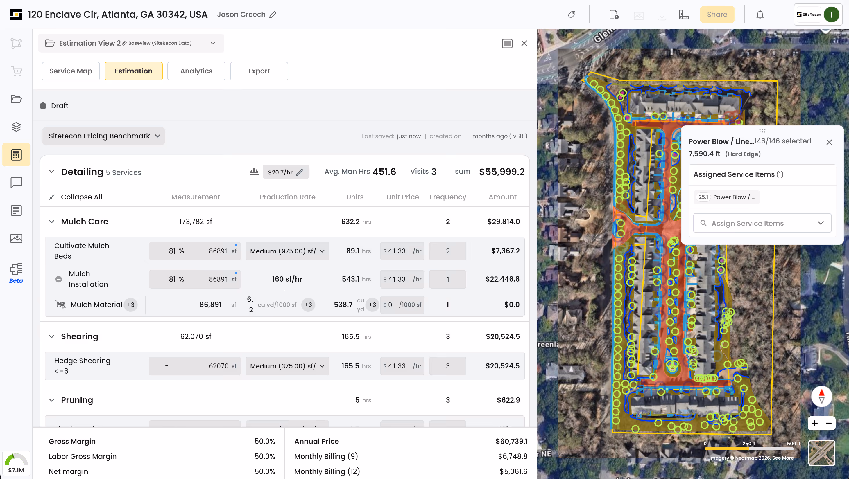
SiteRecon delivers 95–98% measurement accuracy. For initial estimates and quantity takeoffs, this exceeds what most manual measurements achieve. For final design, many professionals use SiteRecon as their starting point.

Can estimators still adjust AI measurements manually?

Yes. SiteRecon’s self-measurement tools let you draw, adjust, and refine any measurement on the platform. You’re always in control.

How does SiteRecon handle properties with complex landscape features?

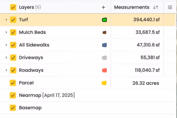
Multi-layer mapping lets you overlay turf, hardscape, irrigation, tree canopy, and custom zones. For highly complex sites, our Expert Done-For-You service provides human-verified measurements.

Get Started Today

Transform Your Estimating Workflow

See how SiteRecon helps estimators and designers produce more accurate bids in a fraction of the time.