
AI-Powered Takeoff Software for Utility and Site Work Contractors
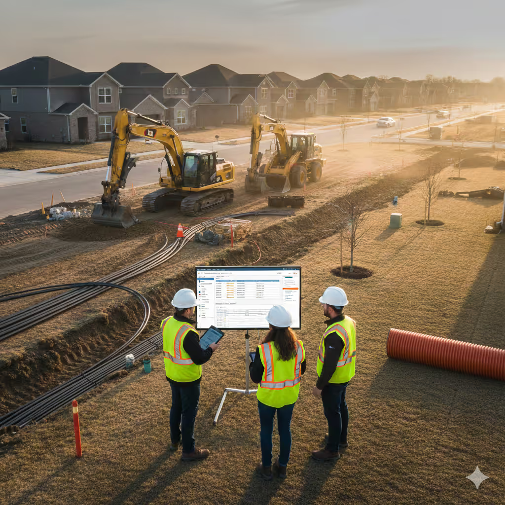
When a developer needs pricing for 2,400 linear feet of water main installation, you can't afford to guess on excavation volumes, trenching footage, or backfill tonnage. SiteRecon gives you engineering-grade measurements in minutes—so you can respond to municipal and commercial opportunities while competitors are still scheduling site visits and utility locates.

12,000+ Miles of Utility Corridors Mapped | Average ROI: 8x First Season | Trusted by 600+ Utility & Site Work Contractors


Measure Once. Price Right. Build Infrastructure.
Every feature drives toward the same outcome: sustainable, profitable growth for utility and site work contractors who refuse to guess their way to success.

Cut estimating time by 75% while eliminating dangerous excavation miscalculations
Cut estimating time by 75% while eliminating dangerous excavation miscalculations
Cut estimating time by 75% while eliminating dangerous excavation miscalculations

Accelerate your pipeline and increase close rates up to 25%
Accelerate your pipeline and increase close rates up to 25%
Accelerate your pipeline and increase close rates up to 25%
.avif)
Build takeoffs with quick turnaround and win bids by managing costs and identifying potential site issues early
Build takeoffs with quick turnaround and win bids by managing costs and identifying potential site issues early
Build takeoffs with quick turnaround and win bids by managing costs and identifying potential site issues early
Use technology for site-specific conditions precision and implementing rigorous site audit reviews to price bids
Use technology for site-specific conditions precision and implementing rigorous site audit reviews to price bids
Use technology for site-specific conditions precision and implementing rigorous site audit reviews to price bids
Trusted By Today's Most Reliable Utility and Site Work Companies
Join thousands of contractors who've transformed estimating from bottleneck to competitive advantage
Utility and site work takeoff software that protects margins and wins profitable infrastructure projects
SiteRecon brings property measurements, excavation calculations, equipment planning, and professional proposals together in one platform—making it faster to bid accurately, easier to protect margins, and simpler to scale your utility business without adding estimating overhead.
AI-Powered Property Takeoffs
For excavation zones, trenching routes, and utility corridors
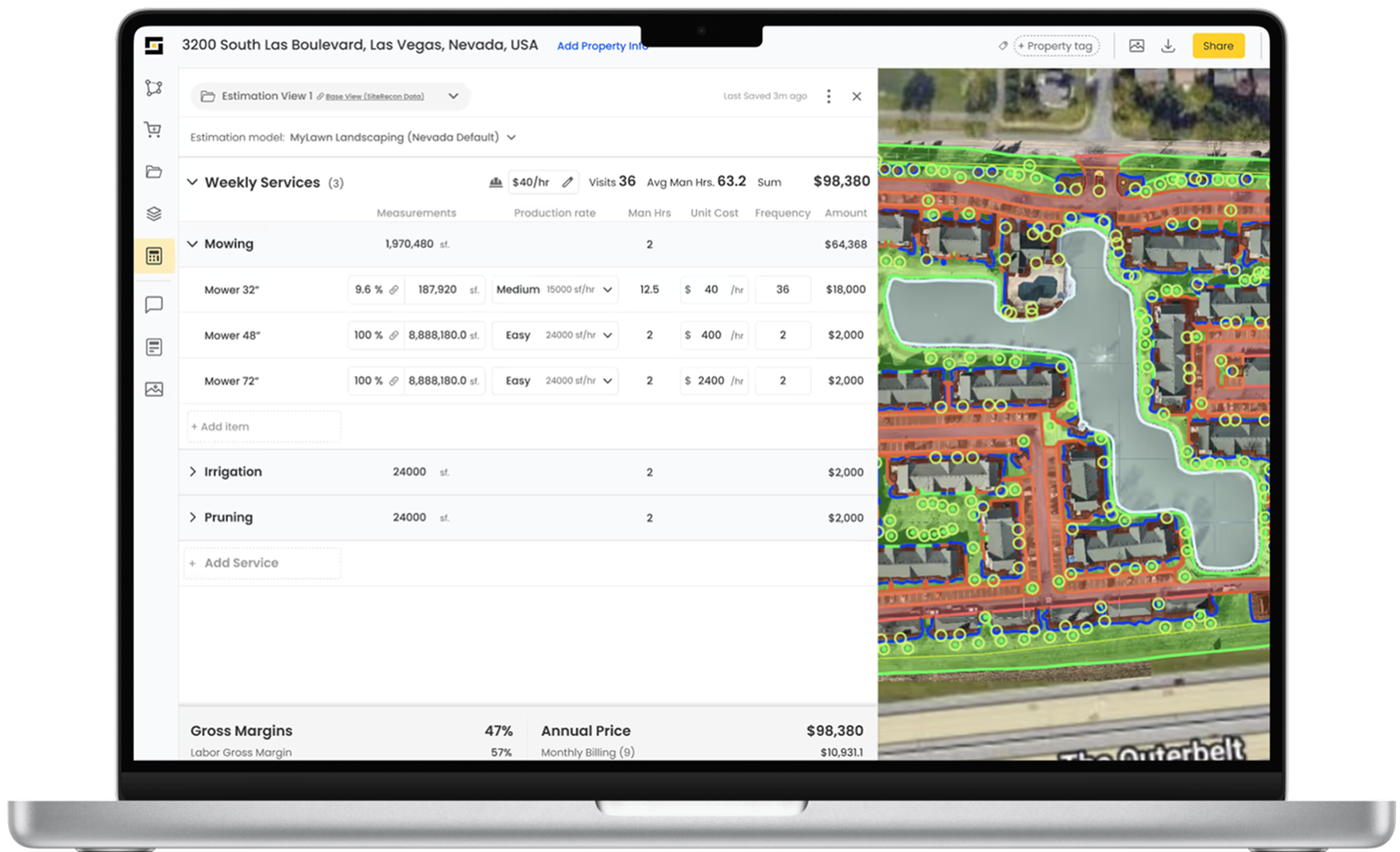
AI-powered measurements in 10-15 minutes with 95%+ accuracy—no site visit required. Measure trenching linear footage, excavation zones, utility corridors, and restoration areas for municipal mains and commercial site work.
Expert Done-For-You Measurements
For complex utility takeoffs
SiteRecon's measurement team handles complex projects in 24-48 hours—no staff training required. We measure utility corridors, depth profiles, existing infrastructure conflicts, and restoration requirements for multi-utility corridors and municipal installations.
Self-Measurement Tools
For partial projects and service connections
Draw exact work zones for scope additions—building service connections, meter installations, or restoration areas. You define the boundaries, we calculate excavation volumes and backfill tonnage instantly.
Multi-Layer Infrastructure Mapping
For underground cost accuracy
Map 12+ project layers affecting margins: soil types, utility corridor widths, excavation depths, existing infrastructure, access constraints, and restoration zones. Know equipment and crew requirements before breaking ground.
Bulk Property Measurements
For development-wide prospecting
Pre-measure entire residential developments or municipal systems. Upload 30-100 addresses for strategic bidding. Have proposals ready immediately when municipalities release utility extension RFPs.
Site Documentation and Progress Tracking
For field accountability
Crews capture geo-tagged photos, verify installation depths, and document backfill operations in real-time. Build defensible records for inspections, change orders, and as-built documentation.
Integrate SiteRecon into Your Utility Contractor Business Stack
Sync SiteRecon measurements into your existing project management and business tools—so you can move from property measurement to professional proposal to project tracking without re-entering data.
ServiceTitan
Enterprise operations management for large utility contractors.
JobTread
Project management and job costing for construction trades.
Clio
Scheduling, invoicing, and CRM for service contractors.
BuilderTrend
Construction scheduling and project management software.
Earthapro
Earthwork and grading estimating for excavation contractors.
ProjectPro / Construction365
Microsoft-based ERP for construction businesses.
Jobber
Simple scheduling and invoicing for growing utility contractors.
See How Professional Utility Contractors Estimate $5M+ in Annual Infrastructure Work
Take an interactive 5-minute tour and watch how SiteRecon transforms a 4-hour site visit and 6-hour estimate into a 30-minute professional utility proposal—with excavation accuracy that protects your margins.
The Best Utility and Site Work Estimating Software for Infrastructure Contractors
SiteRecon is more than property measurement software—it's a complete estimating and project planning platform for utility and site work contractors who refuse to guess their way to profitability. Built specifically for underground infrastructure professionals tired of losing profitable work to slow estimates, inaccurate excavation calculations, and project margin disasters.
Whether you're managing 10 utility installation projects or scaling to 150+ municipal and commercial infrastructure jobs across multiple crews, SiteRecon keeps you accurate, competitive, and on track to win profitable underground work every season.
How utility and site work contractors use SiteRecon:
- Municipal engineers trust proposals with engineering-grade measurements, utility corridor maps, and defensible quantity calculations
- Commercial developers need fast responses to site utility and infrastructure opportunities
- Utility companies require accurate installation quantities for budget approval and contractor selection
- General contractors demand defensible documentation for subcontractor bidding and change order management
What separates SiteRecon from manual site visits and spreadsheet estimating:
Win more profitable infrastructure contracts with professional, branded proposals that include tiered service options (basic/full-service/premium), color-coded utility corridor maps showing excavation zones and restoration areas, and defensible pricing that withstands municipal procurement scrutiny and competitive pressure from low-ball operators.
Eliminate margin-killing guesswork with AI-powered measurements and mathematical excavation precision that ensure every utility bid reflects your actual trenching linear footage, excavation volumes, backfill tonnage, equipment costs, and restoration requirements—no more "gut feel" estimates that cause 25-40% variance between bid and final costs.
Respond to opportunities instantly with bulk property measurements and same-day proposal generation that help you compete when municipalities release infrastructure RFPs. While competitors schedule site visits and manually calculate quantities, you're sending professional utility proposals with equipment deployment plans.
Protect revenue during construction with remeasurement tools that document subsurface condition changes, change order calculators that price additional work (rock excavation, utility conflicts, contaminated soil) accurately, and historical project data that prevent leaving money on the table when unexpected conditions arise.
Frequently Asked Questions
SiteRecon uses AI-powered technology to automatically identify and measure excavation zones, trenching routes, utility corridors, grading areas, and restoration zones from high-resolution satellite imagery—delivering 95%+ accurate measurements in 10-15 minutes without requiring site visits for most municipal and commercial utility projects.
Yes. SiteRecon stores all property measurements and project data, allowing contractors to quickly remeasure areas to document scope changes (extended trenching runs, additional laterals, expanded restoration), calculate additional excavation and backfill quantities, adjust for subsurface condition changes (rock, contamination, utility conflicts), and generate professional change order pricing in minutes.
Absolutely. SiteRecon scales from single-project measurements to bulk portfolio analysis, making it valuable for contractors managing anywhere from 5 to 150+ utility and site work projects annually. Many smaller contractors use SiteRecon to compete against larger companies by delivering faster, more professional municipal proposals.
Yes. SiteRecon's AI-powered takeoff tools can map and measure one utility project or entire municipal systems. Upload 50-100 property addresses and receive accurate measurements for strategic infrastructure bidding. Measure excavation zones, trenching routes, utility corridors, and grading areas with 95%+ accuracy—from one service lateral to 10+ miles of water main installation.
SiteRecon estimates include: linear feet of trenching by depth, cubic yards of excavation, tons of backfill material, restoration square footage, equipment hours by type (excavators, loaders, trenchers), crew labor costs, material requirements (pipe, bedding, backfill), traffic control needs, overhead allocation, and profit margin—all calculated automatically from measurements and your cost inputs.
SiteRecon applies your trench width and depth specifications to exact linear footage measurements and calculates cubic yards of excavation accounting for trench box requirements and spoil pile expansion factors (typically 25-30%). Input your excavation cost per cubic yard and SiteRecon calculates total earthwork investment including backfill requirements.
Yes. SiteRecon works for all utility installation types: water distribution mains and services, sanitary and storm sewer lines, electrical duct banks and conduit, telecommunications fiber and conduit, natural gas distribution and services, site utilities for commercial development, and complete subdivision infrastructure.
Yes. SiteRecon consolidates expert-validated production rates for utility work including: trenching production (linear ft per day by equipment and soil type), excavation rates (cubic yards per hour), backfill compaction rates, pipe installation speeds, and restoration timelines. Compare your actual rates against benchmarks to improve efficiency and bidding accuracy.
Yes. Input your equipment hourly rates, labor costs, material pricing (pipe, bedding, backfill), traffic control costs, and overhead once. SiteRecon generates detailed utility estimates automatically whenever you measure a project. This eliminates quantity calculation errors and saves 5-8 hours per estimate compared to manual takeoffs and spreadsheet calculations.
Yes. Utility crews use the mobile app to capture geo-tagged photos of subsurface conditions, document utility conflicts, verify installation depths, record soil types, flag rock excavation, and document completion in real-time—giving you defensible documentation for municipal inspections, change orders, and as-built records required for project closeout.
Project managers conduct mobile quality inspections with geo-tagged photos, installation verification, depth confirmations, and crew performance tracking. Quality reports can be shared internally for crew accountability or with municipal inspectors to document installation compliance and quality assurance—building trust for future bid opportunities.
SiteRecon supports estimating for: water distribution mains and laterals, sanitary sewer mains and services, storm drainage systems, electrical duct banks and conduit, telecommunications fiber installation, natural gas distribution lines, site grading and earthwork, access road construction, parking lot underground utilities, and complete subdivision infrastructure.
Yes. Generate pricing options for different installation methods, restoration approaches, or project phasing. Compare open-cut trenching vs. directional boring costs. Show municipalities standard restoration vs. full-depth paving options. Offering scenario analysis increases win rates and positions value-added services effectively.
SiteRecon delivers 95%+ accuracy for trenching linear footage, excavation zone areas, and restoration measurements—comparable to survey-grade measurements for estimating purposes. For municipal bidding and contractor selection, GPS-accurate satellite measurements provide defensible documentation that protects both you and the municipality from quantity disputes.
Ready to stop guessing and start growing?
Take an interactive 5-minute tour and watch how SiteRecon transforms a 4-hour site visit and 6-hour estimate into a 30-minute professional utility proposal—with excavation accuracy that protects your margins.