
Site Audit
Document Everything. Miss Nothing. Prove Your Work.
Capture property conditions, mark up progress photos, and share job site documentation—all tied directly to your property maps. SiteRecon's site audit tools keep field teams, office staff, and clients aligned with visual proof of work, progress tracking, and professional reports that protect your reputation and your revenue.

Complete Job Site Documentation in One Platform
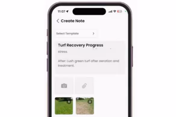
Photo and Video Capture
Snap photos or record videos in SiteRecon's Plato app and they automatically attach to the property record with GPS location, timestamp, and map position. No more lost images, mislabeled files, or "which property was this?" confusion.
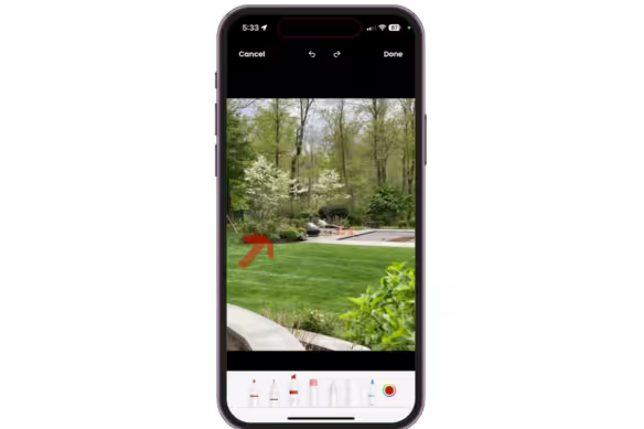
Markup Tools
Draw on photos to highlight issues, circle problem areas, add arrows pointing to completed work, or annotate before-and-after comparisons. Visual markups communicate more clearly than text descriptions ever could—to crews, managers, and clients alike.
Notes and Checklists
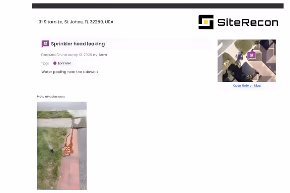
Capture detailed site observations tied to specific property zones. Log equipment conditions, irrigation issues, turf health concerns, or enhancement opportunities with structured notes that sync across your team and inform future service recommendations.

Instant Measurements
Measure turf, hardscape, beds, parking lots, and snow routes remotely using satellite and aerial imagery. Get accurate square footage and linear measurements in minutes instead of hours—no truck rolls, no wasted windshield time.
Multi-Layer Service Mapping
Create detailed property maps with distinct layers for every service type—mowing zones, irrigation coverage, snow priority routes, bed maintenance areas. One measurement session captures everything your crews need to estimate and execute.
Bulk Property Processing
Measuring a portfolio of 50 properties? Upload your list and get complete takeoffs back fast. Scale your estimating capacity without adding headcount—perfect for large commercial bids and multi-site contracts.
What SiteRecon Clients Are Saying About Site Audit
"SiteRecon isn’t just a tool—it’s a partner in growth. It’s helping us win more business, serve our clients better, and scale in ways I never thought possible."

Benefits and ROI Results

Aspire
Lorem ipsum dolor sit amet, consectetur adipiscing elit. Suspendisse varius enim in eros elementum tristique. Duis cursus, mi quis viverra ornare, eros dolor interdum nulla, ut commodo diam libero vitae erat.
BOSS
Lorem ipsum dolor sit amet, consectetur adipiscing elit. Suspendisse varius enim in eros elementum tristique. Duis cursus, mi quis viverra ornare, eros dolor interdum nulla, ut commodo diam libero vitae erat.
Benefits and ROI Results
Timestamped, GPS-tagged photos and videos create an indisputable record of property conditions and completed services. When clients question whether work was done—or done right—you have documentation that settles it instantly.
Site observations sync immediately to the property record. Account managers see crew notes without phone calls, estimators spot enhancement opportunities without site visits, and operations track progress without chasing updates.
Generate polished before-and-after comparisons, project progress summaries, and visual service reports that demonstrate value and justify pricing. Clients see exactly what they're paying for—and why you're worth it.
Explore other features
Frequently Asked Questions About Site Audit
When you capture media in SiteRecon's Plato app, it automatically tags with GPS coordinates, timestamp, and the user who captured it. The system matches location data to your property records, attaching documentation to the correct site and map position without manual filing or uploads.
Yes. SiteRecon's mobile app gives field crews full access to photo capture, video recording, markup tools, and note-taking. Everything syncs in real time, crews document in the field, and office staff see updates immediately without waiting for end-of-day uploads.
Generate before-and-after comparisons, project progress reports, property condition assessments, quality control summaries, and visual service documentation. Reports pull directly from your captured photos, markups, and notes, formatted professionally and ready to share with clients or internal teams.
Absolutely. Build standardized checklists for quality control inspections, seasonal property walkthroughs, irrigation audits, snow response verification, or any recurring documentation needed. Crews follow consistent processes, and you maintain audit trails across every property.
Attach site documentation directly to invoices, service reports, or client emails. When you bill for completed work, include timestamped photos showing the job done. When you recommend enhancements, include annotated images showing exactly why building trust and closing upsells.
Get Started Today
Ready to document every job site, protect your work with visual proof, and impress clients with professional reports?