
Landscape Takeoff Software
Turn Every RFP Into Revenue
Imagine your team responding to every RFP with an accurate bid — so the only thing left is building relationships and following up to win the work. No over or under-bidding.
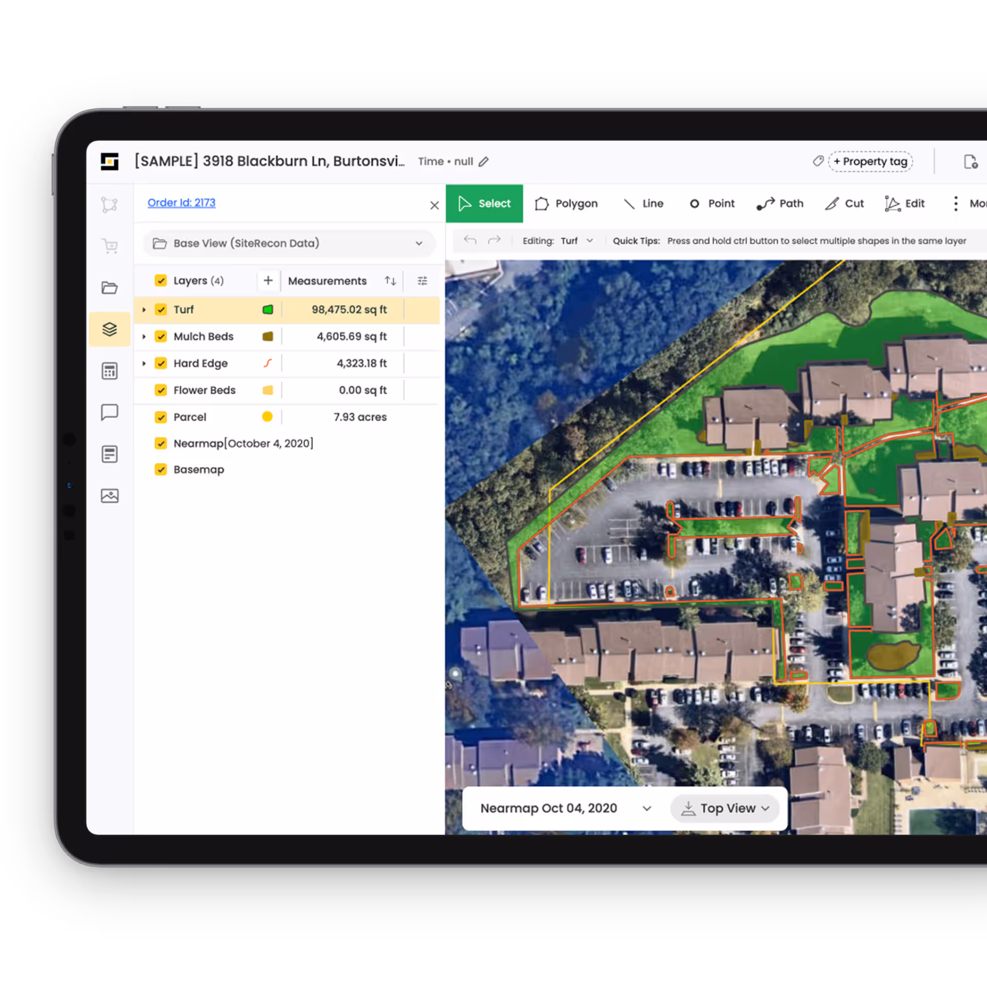
SiteRecon uses advanced AI to pull detailed measurements directly from HD aerial imagery. Your team gets everything they need to bid fast. Seamless ready-to-quote data at the click of a button that helps your estimators stay ahead—your bids go out on time, and your sales team focus on what actually wins contracts—relationships and follow-ups.
Why Landscaping Pros love SiteRecon
Discover how industry leaders have transformed their operations with SiteRecon, achieving remarkable efficiency and growth.
%201.avif)


.avif)
More RFPs should mean more revenue, right?
If your team is stuck with slow takeoffs, your business isn’t winning the bids it should.
Why SiteRecon is the right choice for your business?
SiteRecon doesn’t just make takeoffs faster—it makes your business more scalable.
Guided onboarding process and dedicated Customer Relationship Manager
Open APIs to ensure you can integrate SiteRecon with your current setup
Mobile app to document site conditions on the map and conduct hassle-free site audits
Guaranteed delivery times for takeoff orders
.png)
Frequently Asked Questions
Landscape takeoff software automates the process of measuring properties for landscaping jobs. It uses satellite imagery, parcel maps, and AI to generate accurate measurements of turf, beds, and hardscapes—eliminating the hours of backbreaking work that goes into measuring properties manually - with a measuring wheel or a measuring tape.
SiteRecon’s takeoffs extremely accurate which is the reason why SiteRecon is a trusted mapping partner for 5 out of the top 10 LM150 companies. The AI measures from high-resolution aerial imagery and parcel boundaries, ensuring consistency and precision across every property. Then the AI output goes through two Quality Assessment cycles where real human cartographers look at the data and refine it to meet SiteRecon’s high data delivery standards.
Landscape takeoff software is ideal for commercial landscapers, lawn care companies, and estimators who handle multiple bids each week. It’s especially valuable for businesses looking to speed up proposals, increase bid volume, and improve pricing accuracy.
Yes. SiteRecon offers open APIs and integrates with popular CRMs and estimating software. You can export measurement data into templates or connect it directly to your workflow—reducing manual data entry and saving time.
With SiteRecon Instant, you can get lawn measurements in under 30 seconds. For large commercial properties or multi-site portfolios, takeoffs are typically delivered within 24–72 hours depending on your subscription plan and the size of the property
SiteRecon combines different sources of imagery to get the most complete picture of the site -
-Leaf-off imagery collected during winters to see through tree canopies
-Street imagery to get a view from ground
The above sources are combined with the latest high resolution aerial imagery of the site to extract measurements.
Yes. SiteRecon access the best-in-class aerial imagery from Nearmap to extract measurements. Nearmap imagery is collected over 700 cities within the last 1-9 months. The collection frequency depends on how big your city is. The bigger the city, higher the collection frequency.
Yes. It is possible to place bulk orders on SiteRecon. This how it works -
Upload an excel containing the list of addresses and the measurements needed.
Review if the right location and property outline was picked up for the address.
Click on 'Get measurements'
Properties are mapped at a rate of few dozen per day and the support team follows up to ensure that the data is reviewed and approved.
SiteRecon enables you to share maps with accounts added to your organization's workspace. Everyone added to the workspace can view the maps and measurements
For people outside the team, you can share a map just like sharing a YouTube video - using a web page link.
You Don’t Need More Estimators, You Need Automation
Get more bids out, win more work, and grow without more headcount.

They Replaced Manual Takeoffs—Then Grew 50%
Read how Michael Hatcher & Associates used SiteRecon to speed up measurements—and scale commercial sales, fast.
The Sales Bottleneck? Manual Takeoffs.
This case study shows how Greenery Inc. automated takeoffs and rebuilt its sales engine from the ground up with SiteRecon.